
Last Updated on February 21, 2025 by sanjjeett
The NCERT Solutions have been updated for current academic session, with the new NCERT Book “Exploring Society India and Beyond”. All questions are solved with detailed explanation of each and every questions. In this article, we are providing NCERT Solutions for Class 6 Social Science Chapter 1 Locating Places on Earth. It is a part of NCERT Solutions for Class 6 Social Science series.
Locating Places on Earth NCERT Solutions Class 6 Social Science:
NCERT Solutions for Class 6 Social Science Chapter 1, Locating Places on Earth, offer clear, step-by-step answers to all textbook questions. Expertly crafted, these solutions simplify complex concepts, enhance understanding, and build confidence, helping students excel in their studies.
Exercise
Questions, Activities and Projects
Q. 1. Returning to page 10 and to Fig. 5.2 in Chapter 5 of this textbook, taking the scale to be 2.5 cm = 500 km, calculate the real distance from the estuary of the Narmada River to the estuary of the Ganga River. (Hint: Round off your measurement on the map to an easy number.)
Ans. Let’s measure the distance on the map between estuary of the Narmada River and estuary of the Ganga River. Let’s assume, we measure it to be approximately 5.5 cm.
Since the scale is 2.5 cm = 500 km, we can set up a proportion to calculate the real distance.
2.5 cm = 500 km
1 cm = 500 km/ 2.5
1 cm = 200 km
Convert the measured distance on the map (5.5 cm) to real distance.
5.5 cm × 200 km/cm = 1100 km
So, the real distance from the estuary of the Narmada River to the estuary of the Ganga River is approximately 1100 km.
Q. 2. Why is it 5:30 p.m. in India when it is 12 p.m. or noon in London?
Ans. It is 5:30 p.m. in India and 12:00 noon in London because the time difference between India and London is 5 hours and 30 minutes. India is located East of Greenwich at 82°30’ and 5 hours and 30 minutes ahead of GMT.
Q. 3. Why do we need symbols and colours in the map?
Ans. Symbols and colours are important elements of a map because they can convey a lot of information in a limited space. They can also make maps easier to read and more attractive.
Q.4. Find out what you have in the eight directions from your home or school.
Ans. The eight directions are:
East, southeast, south, southwest, west, northwest, north, northeast.
Q.5. What is the difference between local time and standard time? Discuss it in groups, with each group writing an answer in 100 to 150 words. Compare the answers.
Ans. Standard Time:
- The time of the standard meridian of a country.
- Every country has its own particular standard time, and it remains the same for the whole country.
- Places on the same longitude can often have varying standard time.
Local time:
- Local time refers to time at a particular place, that is the time when the mid-day Sun is directly overhead.
- Different places in the same country have their own local times.
- Places on the longitude always have the same local time.
Q. 6. Delhi’s and Bengaluru’s latitudes are 29°N and 13°N, respectively; their longitudes are almost the same, 77°E. How much will be the difference in local time between the two cities?
Ans. The difference of time between two places depends on the difference of longitude. As the longitudes are almost same, there is no difference in local time between the two cities.
Q. 7. Mark the following statements as true or false; explain your answers with a sentence or two.
- All parallels of latitude have the same length.
Ans. False. They are not of the same length. The length of a degree of latitude varies depending on the distance from the equator. - The length of a meridian of longitude is half of that of the Equator.
Ans. False. All meridians are of equal length. The meridians cut the equator at a right angle and are all in the same length unlike parallels
- The South Pole has a latitude of 90°S.
Ans. True. This is because the distance from the equator to the either pole is one-fourth of a circle around the Earth, which is 90°. - In Assam, the local time and the IST are identical.
Ans. False. Assam officially follows IST, its local solar time would be about 30 minutes ahead of IST. - Lines separating the time zones are identical with meridians of longitude.
Ans. True. Time zones are generally based on the meridians of longitudes, with each time zone spanning 15° of longitude. - The Equator is also a parallel of latitude.
Ans. True. The Equator is also a parallel of latitude, also known as a line of latitude diving the Earth into the Northern and Southern hemispheres at 0° latitudes.
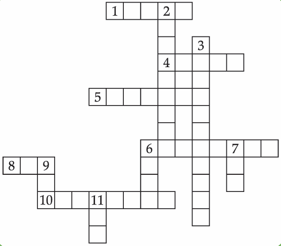
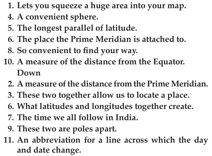
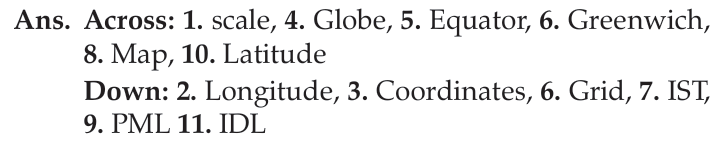
Solve the crossword below.
- Across
Related posts
| Locating Places on Earth Case Study Questions | Locating Places on Earth Assertion Reasoning |
🔗 Explore More: Find all NCERT solutions here → NCERT Solutions for Class 1 to 12
Also check
- NCERT Solutions for Class 6 Social Science Chapter 7 India’s Cultural Roots
- NCERT Solutions for Class 6 Social Science Chapter 6 The Beginings of Indian Civilisation
- NCERT Solutions for Class 6 Social Science Chapter 5 India, that is Bharat
- NCERT Solutions for Class 6 Social Science Chapter 4 Timeline and Sources of History
- NCERT Solutions for Class 6 Social Science Chapter 3 Landforms and Life
- NCERT Solutions for Class 6 Social Science Chapter 2 Ocean and Continents
- NCERT Solutions for Class 6 Social Science Chapter 1 Locating Places on Earth

Frequently Asked Questions (FAQs) on Locating Places on Earth Class 7 NCERT Solutions
Q1: What are NCERT Solutions?
A1: NCERT Solutions are detailed, step-by-step answers to the questions provided in the NCERT textbooks. They are designed to help students understand the concepts thoroughly and prepare effectively for their exams.
Q2: Why are NCERT Solutions important for students?
A2: NCERT Solutions are crucial for students because they offer clear explanations and step-by-step guidance on solving textbook problems. They help in building a strong foundation in each subject, making it easier for students to grasp complex concepts and perform well in their exams.
Q3: Are the NCERT Solutions available for free on Xam Content?
A3: Yes, all the NCERT Solutions on our website are available for free. We believe in making education accessible to all students, ensuring that everyone can benefit from our resources without any cost.
Q4: How can NCERT Solutions help in exam preparation?
A4: NCERT Solutions help in exam preparation by providing thorough explanations and solutions to textbook problems. They ensure that students understand the core concepts and are well-prepared for any type of question that may appear in their exams.
Q5: Are NCERT solutions enough for scoring good marks in Class 6 Social Science exams?
A5: Yes, NCERT solutions cover the entire syllabus prescribed by CBSE for Class 6 Social Science. If students thoroughly understand and practice these solutions, they can definitely score well in their exams. However, it’s also beneficial to supplement your studies with additional reference materials and practice questions. For various types of questions asked in social science exam, you can visit xamcontent.com.